


VFRnav – Flight Navigation
คำอธิบายของVFRnav – Flight Navigation
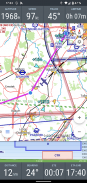
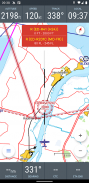
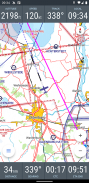
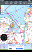
VFRnav เป็นแอปพลิเคชั่นนำทางที่ออกแบบมาโดยเฉพาะเพื่อตอบสนองความต้องการของนักบินที่บินภายใต้กฎการบินด้วยภาพ (VFR) แอปนี้รวมแผนที่เคลื่อนที่ในรูปแบบ ICAO เข้ากับคุณสมบัติการวางแผนและการบันทึกที่ครอบคลุม ช่วยให้การนำทางเที่ยวบินเชื่อถือได้และมีประสิทธิภาพ
คุณสมบัติที่สำคัญ:
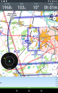
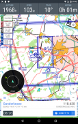
• การนำทางตามแผนที่: แสดงเส้นทางการบินบนแผนที่สไตล์ ICAO พร้อมการอัปเดตตำแหน่งแบบเรียลไทม์
• การทำงานแบบออฟไลน์: ทำงานได้อย่างสมบูรณ์แบบออฟไลน์หลังจากการตั้งค่า; ไม่จำเป็นต้องเชื่อมต่ออินเทอร์เน็ตระหว่างเที่ยวบิน
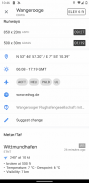
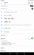
• ฐานข้อมูล: ข้อมูลที่ครอบคลุมเกี่ยวกับสนามบิน จุดอ้างอิง และอุปกรณ์ช่วยนำทางในประเทศต่างๆ ในยุโรป
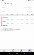
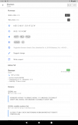
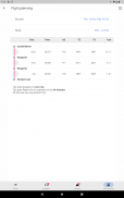
• การวางแผนเที่ยวบิน: ช่วยในการวางแผนเส้นทาง การคำนวณเชื้อเพลิง และการประมาณเวลาเที่ยวบิน บูรณาการข้อมูลสภาพอากาศและ NOTAM สำหรับเส้นทางที่วางแผนไว้โดยอัตโนมัติ
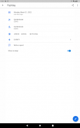
• สมุดจดรายการต่างเที่ยวบินดิจิทัล: บันทึกเวลาขึ้นและลงจอดโดยอัตโนมัติ ส่งออกข้อมูลเที่ยวบินเป็นไฟล์ KML เพื่อใช้ในแอปพลิเคชันเช่น Google Maps
• เซ็นเซอร์ภายนอก: รองรับการทำงานร่วมกับเครื่องรับ GPS ภายนอกและแหล่งข้อมูลการจราจร (เช่น FLARM, Stratux, CCAS, SafeSky, ADS-B) ผ่านทาง WiFi หรือ Bluetooth
ข้อกำหนดทางเทคนิค:
• Android เวอร์ชัน 5 ขึ้นไป
• ความละเอียดหน้าจอขั้นต่ำ 480x800 พิกเซล
• พื้นที่เก็บข้อมูลว่างอย่างน้อย 200 MB
รูปแบบใบอนุญาต:
สามารถทดสอบ VFRnav ได้อย่างสมบูรณ์โดยไม่มีข้อจำกัดก่อนซื้อ ใบอนุญาตมีค่าใช้จ่าย 49.95 ยูโร และให้การเข้าถึงการอัปเดตฟรีหนึ่งปี หลังจากช่วงเริ่มต้น สามารถต่ออายุข้อกำหนดการอัปเดตได้ แอพยังคงทำงานได้อย่างสมบูรณ์โดยไม่คำนึงถึงการอัปเดต ใบอนุญาตเป็นส่วนบุคคลและใช้ได้กับอุปกรณ์ Android สูงสุดสามเครื่องที่เชื่อมโยงกับบัญชี Google เดียวกัน หมายเหตุ: ใบอนุญาตสำหรับอุปกรณ์ Android ไม่ได้ให้สิทธิ์การใช้งานสำหรับอุปกรณ์ Apple
ข้อสงวนสิทธิ์:
ไม่สามารถรับประกันความถูกต้องและครบถ้วนของข้อมูลที่ให้ไว้ได้ การใช้ถือเป็นความเสี่ยงของคุณเอง ข้อมูลที่แสดงในแอปควรได้รับการตรวจสอบเทียบกับแผนภูมิการบินอย่างเป็นทางการเสมอ
VFRnav – Flight Navigation - ข้อมูล APK
เวอร์ชั่น APK: 4.11.0แพ็คเกจ: com.flugbetrieb.VFRnavเวอร์ชั่นล่าสุดของVFRnav – Flight Navigation
เวอร์ชั่นอื่น


แอปในประเภทเดียวกัน


